The Sepulveda Basin portion of the L.A. River Recreation Zone is one of two segments where the Los Angeles River has a natural earth bottom, fostering a riparian habitat. The Sepulveda Basin River Recreation Zone extends for two miles and features some of the best kayaking, fishing, and bird watching in the L.A. basin. It is a quiet retreat from the neighboring commotion of urban activity.
The Sepulveda Basin Recreation Area was originally designed as a flood control basin, and its 2,000-acre expanse includes a wildlife reserve with crucial habitat space; the Sepulveda Dam; the Tillman Water Reclamation plant, which treats 40 million gallons of water per day; Anthony C. Beilenson Park; Lake Balboa; and The Japanese Garden.
Read more about the Rules and Safety recommendations for the River Recreation Zone (RRZ) here.
ACCESS POINTS
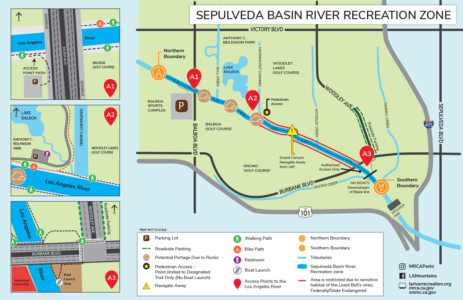
The Sepulveda Basin River Recreation Zone extends approximately two miles from Balboa Boulevard, just south of Victory Boulevard, to just west of Woodley Avenue. There are three available access points depending on the activity. Boat launch is available at both the North and South Boundary Access points. No boat launch is permitted at the Middle Access Point, it is ONLY for pedestrians on the designated trail.
Access to the Sepulveda Basin River Recreation Zone is west of Woodley Avenue on Burbank Boulevard. Use the approximate address of 16212 Burbank Boulevard, Encino, CA 91436 for mapping apps.
- North Boundary Access Point, off Balboa Boulevard south of Victory Boulevard.
- Middle Access Point, Pedestrians ONLY. Next to Hayvenhurst Channel. Access limited to designated L.A. River Trail only – boat launch NOT permitted.
- South Boundary Access Point, off Burbank Boulevard near Woodley Avenue, river left.
DIRECTIONS TO THE NORTH BOUNDARY ACCESS POINT (A1)
By Bicycle: Take the Metro Orange Line bikeway along Victory Boulevard. Turn left on Balboa Boulevard and proceed south. Pass the automobile entrance to Anthony C. Beilenson Park and continue to the L.A. River Bridge. Continue on the bike path to reach the Middle Access Point (A2).
By Transit: Take the Metro Orange Line and exit at Balboa Boulevard. Walk south to the L.A. River Bridge to the access point located before the bridge at river right.
By Car: Exit the 405 Freeway at Burbank Boulevard in Van Nuys. Go west on Burbank Boulevard. Turn right onto Balboa Boulevard. Parking is available at the Sepulveda Basin Sports Complex on the right side. Walk up north to the L.A. River bridge to the access point at river right.
Alternately, exit the 101 Freeway in Encino at Balboa Boulevard. Go north on Balboa Boulevard. Parking is available at the Sepulveda Basin Sports Complex on the right side. Walk up north to the L.A. River bridge to the access point, river right.
DIRECTIONS TO THE SOUTH BOUNDARY ACCESS POINT (A3)
By Bicycle: Take the Metro Orange Line bikeway. Turn right at Woodley Avenue and proceed south. Keep right and continue to Burbank Boulevard. Cross Burbank Blvd and walk west to continue to the access point located before the bridge. There are no bike racks at this time.
By Transit: Take the Metro Orange Line and exit at Woodley Avenue and proceed south to the L.A. River. Walk south on Woodley. Cross Burbank Blvd and walk west to continue to the access point located before the bridge, on river left.
By Car: Exit the 405 Freeway at Burbank Boulevard in Van Nuys. Go west on Burbank Boulevard. Turn right onto Woodley Avenue. Roadside parking available. Follow parking regulation signs. Cross Burbank Blvd and walk west to continue to the access point located before the bridge, on river left.
Alternately, exit the 101 Freeway in Encino at Balboa Boulevard. Go north on Balboa Boulevard. Turn right onto Burbank Boulevard. Turn left onto Woodley Avenue. Roadside parking available. Follow parking regulation signs. Cross Burbank Blvd and walk west to continue to the access point located before the bridge, on river left.
KAYAK
Any member of the public may launch a non-motorized, steerable boat, such as a kayak or canoe. See site map for the access points (A1 & A3). Swimming is not permitted. River conditions and hazards are subject to change without notice. For those who do not own their own equipment, several organizations provide rentals and guided tours of the River Recreation Zone. See here for outfitters [Link to outfitters page]. This portion of the river typically has Class I flows where the water is easy to paddle in. There are three spots where it may be difficult to navigate one’s boat over rocks. The kayaker will likely need to get out of the boat and portage (walk) their boats over the rocks. Portage areas are indicated on the map.
FISH
Fishing is allowed along the non-restricted banks of the Los Angeles River and from a boat in the Sepulveda Basin. Fishing is not permitted on the restricted banks which stretch from Hayvenhurst Channel to Burbank Boulevard, to protect wildlife habitat. A fishing license from the California Department of Fish and Wildlife is required. Fish species in the Los Angeles River include largemouth bass, tilapia, green sunfish, and mosquito fish.
EXPLORE
There is much to explore within the Los Angeles River Recreation Zone at the Sepulveda Basin. Native habitat and wildlife flourishes in the soft-bottom portion of the river. You are welcome to walk along the banks of the river that are clearly marked with signs. Swimming is not permitted.
The L.A. River Recreation Zone is in the Pacific Flyway, which is a major north-south flyway for migratory birds and a huge variety of birds visit here to hunt for food and rest. Great Blue Heron are often seen feeding on fish and frogs. Duck, osprey, and snowy egrets are frequently sighted near the densely vegetated shoreline.
This area is also home many bird species including the Federally Endangered and State Endangered Least Bell’s Vireo bird. Portions of the riverbanks are restricted to fishing and pedestrian use during nesting season to protect their sensitive habitat. These areas are indicated by red lines on the map.


